
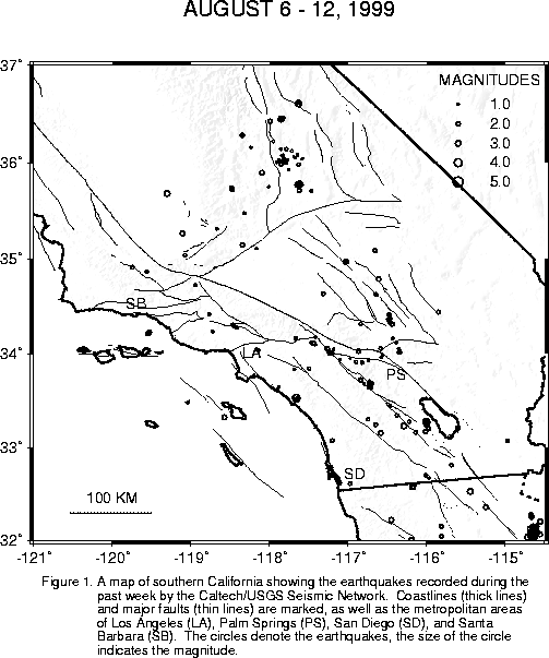
There were two more M3+ Cerro Prieto quakes yesterday afternoon: a M3.1 at 3:43 pm and a M3.2 at 5:20 pm.
I am getting a lot of e-mail questions about "exactly what is going on down there south of Yuma, anyway?". So I thought I'd include a little background. Coachella Valley, Imperial Valley, and the Cerro Prieto area to the south (the site of the current swarm) actually constitute the northern end of the the East Pacific Rise, an ocean ridge (spreading center). To the north of this area, on the western shore of the Salton Sea near Bombay Beach, the plate motion is transferred onto the strike-slip San Andreas fault. The only reason that the Coachella, Imperial Valley's etc. are not underwater (the Salton Sea is below sea level) is the enormous amount of sediments delivered by the Colorado River. Basically, the Colorado River delta forms a dam which holds back the sea. Underneath all this sediment, however, sea floor spreading is going on as usual, with alternating transform (strike-slip) and spreading (normal faulting) segments. The major transform faults, like the Imperial fault, can support quakes up to about M7, which the Imperial fault did in 1940 and 1979. The areas with the sea floor spreading going on underneath, such as the Brawley Seismic Zone or the Cerro Prieto Seismic Zone, are prone to earthquake swarms. A swarm is a clump of earthquakes in space and time, with no really obvious main shock. Swarm members can be as large as the M5's, but, as with other earthquakes, the small swarm members are the most common. A swarm can last from a few days up to a few months, with that latter usually on an intermittent basis. The current Cerro Prieto swarm seems very typical of this type of activity.
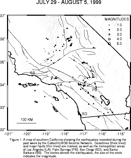
The Cerro Prieto swarm (about 45 miles south of Yuma) continues. Over the weekend, there were a number of M3+ members: a M3.7 at 4:31 pm on Friday, a M3.0 at 5:14 pm on Friday, a M3.1 at 12:07 pm, a M3.3 at 12:11 pm, and a M3.5 at 12:17 pm on Sunday, all on Sunday.
There was also a M2.9, at 5:48 pm Friday, 3 miles southwest of Morongo Valley. This quake is about 2 miles from North Palm Springs sequence of 1986 (largest M5.6).
Another small quake, M2.8, occurred just after midnight (12:00 am) on Saturday, 4 miles north of Lake Henshaw, close to the Elsinore fault zone.
Excluding the Cerro Prieto quakes, the largest quake in our network over the weekend was a M3.4 at 8:50 am on Saturday, located 7 miles east-southeast of Idyllwild.
Last but not least (if it were any smaller, I would not talk about it!), there was a M2.5 along the San Jacinto fault zone, 11 miles east-southeast of Anza, at 5:27 am today.
Believe it or not, with small activity going on at all these places, not quakes were reported felt this weekend!
We recorded and analysed 232 earthquakes in the past week. Click here to see a summary and map .
There was another M3+ member of the Cerro Prieto sequence this morning at 11:41 am. The location was 47 miles south of Yuma AZ, and the magnitude was M3.5.
At 6:04 am this morning, there was a M4.7 quake located in northern Baja, 51 miles south of Yuma, Arizona. It was the largest member of a small swarm. In fact, there has been continuing activity just north of that location for the past couple of weeks. It is not clear whether or not this morning's quake was felt in the Imperial Valley or in Yuma.
We recorded and analysed 222 earthquakes in the past week. Click here to see a summary and map .
Yesterday, at 5:44 pm, there was a M2.5 quake 12 miles east of Anza, in the San Jacinto fault zone. Then, at 12:50 am, there was a M3.1 Landers aftershock, located 19 miles north of Yucca Valley. Neither quake has been reported felt.
And one more: a M2.7 at 2:13 pm, located 10 miles north-northwest of Borrego Springs, near the San Jacinto fault system.
There has been a slew of earthquakes worth mentioning these past few days. The most recent, a M2.9 today (Tuesday) at 10:34 am located 4 miles north-northwest of Beaumont, is a continuation of activity that started in that area yesterday morning (Monday, the 16th) at 4:13 am with a M2.9 earthquake. Later that day at 11:32 pm there was a M2.7 earthquake in the same general location.
Earlier today, at 5:24 am a M2.9 occurred 7 miles east of Mt. San Gorgonio. There are no reports this earthquake was felt.
Last Sunday afternoon there were two notable earthquakes: a M2.5 earthquake at 2:53 pm, located 4 miles south-southwest of Devore in San Bernardino county, and a M3.2 earthquake 7 miles north of the town of Lake Isabella at 4:25 pm. The Lake Isabella event was felt in the epicentral area.
And last but not least on Saturday evening (the 14th) another earthquake was felt - a M3.2 occurring 7 miles north-northwest of downtown Santa Barbara. It happend at 9:47 pm.
We recorded and analysed 214 earthquakes in the past week. Click here to see a summary and map .
It has been pointed out to me that I let the whole month of July pass without including the quarterly earthquake statisitics. So here they are:
-------------------------------------------------------------------- Totals listed below apply to the area within a polygon bounded by the following latitude, longitude pairs: 35.0N, 121.0W; 37.0N, 119.0W; 37.0N, 115.0W; 32.5N, 115.0W; and 32.5N, 121.0W.1st quarter 2nd quarter 3rd quarter 4th quarter all 3.0+ all 3.0+ all 3.0+ all 3.0+ 1986 3,040 16 2,865 19 6,634 192 2,300 38 1987 1,679 24 1,887 36 2,341 38 5,748 198 1988 2,749 40 2,128 45 2,195 30 2,208 27 1989 2,528 46 2,340 21 2,323 19 2,335 26 1990 2,850 56 2,293 43 1,859 27 2,039 31 1991 1,679 10 1,843 32 2,081 21 2,337 27 1992 3,389 37 10,084 741 25,849 808 9,775 181 1993 4,799 41 5,152 58 5,039 46 4,419 34 1994 10,735 418 5,766 42 5,221 48 4,813 39 1995 3,639 28 3,788 37 8,252 88 7,733 49 1996 5,735 56 3,966 32 3,690 23 4,660 50 1997 3,699 39 3,276 54 3,193 31 2,443 27 1998 3,590 56 2,830 27 2,655 37 2,352 29 1999 2,253 35 2,546 58 --------------------------------------------------------------------
At 11:44 am this morning, there was a M3.5 quake, located 3 miles west of Salton City (or 42 miles northwest of El Centro). This is almost the same location as a M3.3 early Monday morning. The focal mechanism is strike-slip. We have received no "felt" reports.
A quake was widely felt throughout Orange County at 11:33 pm last night. The initial magnitude estimate was M3.4, but a subsequent analysis revised it upward to M3.6. The focal mechanism was mostly oblique thrust, or, in other words, mostly strike slip with a component of thrust as well. Neither plane in the focal mechanism is consistent with the nearby Christianitos fault.
Here is a note on why we are so reluctant to assign small quakes to named faults. The likely rupture length for a M3.5 quake is only about 500 meters. While many quakes of this size range occur on or near the major faults, many do not. We have to assume that the ones that do not are on smaller faults, perhaps not even much longer than the assumed rupture. Such a fault might not intersect the ground surface at all, where a geologist could map it. So, if a small quake locates near a named fault, we take the further step of looking at the focal mechanism. The focal mechanism is computed from the direction of first motion of the seismic waves themselves, and always gives us two possible fault planes, at right angles to each other, with no way except knowledge of the regional geology to tell which would be the real fault plane. If one of those planes is consistent with the known nearby fault, then it is possible that that fault caused the quake. If neither plane is consistent, then it must have been another, presumably small, fault. It is truly impossible to say for sure, unless the quake is large enough (usually above M6) to cause surface rupture.
A few small quakes occurred over the weekend, including a M2.8 about 27 miles northwest of Bakersfield. It occurred at 5:57 am on Saturday. Another M2.8 occurred at 8:00 pm on Saturday, this time 5 miles east-southeast of Borrego Springs. At 3:34 pm on Sunday, there was another Baja quake, M3.3, located 43 miles south of Yuma AZ. Then, at 5:56 am today, there was a M3.3, located 3 miles west-southwest of Salton City (or 42 miles northwest of El Centro). At 6:32 am today, the Saline Valley, 23 miles east of Lone Pine, was hit by a M3.1. As far as we know, none of the above mentioned quakes were felt.
Northern Baja had a few quakes overnight. Two noticable ones, a M3.3 at 7:34 pm last night and a M3.2 at 6:43 am this morning, occurred 46 miles south of Yuma, Arizona. There have been several small quakes near this location in the past few days, including a M3.0 yesterday morning. A third noticable event, M3.0, occurred at 12:08 am today, 10 miles south-southeast of Calexico.
We recorded and analysed 168 earthquakes in the past week. Click here to see a summary and map .
Here is a brief note on the Nevada quakes this morning, even though they are outside of our coverage area. The largest was a M5.6 (NEIC) or M6.2 (Menlo Park), located about 72 miles east of Bishop, California, at 9:09 am. The largest aftershock occurred about 21 minutes later, with a magnitude of M5.2. The quake was reported felt in Las Vegas, Death Valley, and the upper Owens Valley. The epicentral area is very sparsely populated.
Later arriving waves and aftershocks from this sequence confused the Southern California Seismic Network software a bit, and caused the web site maps to be peppered by small phantom earthquakes, that actually did not exist. At the moment, we believe we have done a pretty good job of removing these erronous events, but there might still be a few lingering.
Also, please note that we are having telemetry problems for stations in the general area covering Ventura County up to the Grapevine, which also have been causing phantom earthquakes. We remove these as quickly as possible also. We are aware that some users have been concerned that we were "hiding" events when we do this, but they are actually not real earthquakes, just problems with the hardware.
![]()