
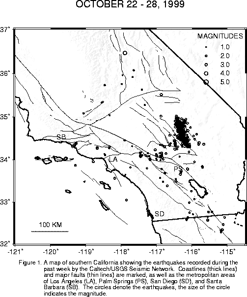
The automatic processing system detected and located 972 earthquakes in the past week. Click here to see a summary and map .
We are still not able to keep up with our data processing. Therefore, the number of events listed is still a minimum figure. This week's earthquake list is a mixture of automatic (but reviewed and approved) epicenters, and results of the analysts' work.
Since the M5.0 Hector aftershock on Friday, there have been 44 more aftershocks of M3.0 and larger, including a M4.6 on Monday morning at 11:26 am. The location of the M4.6 was not far from the hypocenter of the mainshock, in the center of the north-south striking aftershock zone. There have also been, of course, many smaller quakes. We do not have a total, however, as data processing is still under way.
The total number of M3.0 and greater for the Hector sequence is now 268.
Also on Monday, there was a M4.0 at 3:59 pm, located in Owens Valley, 13 miles southeast of Lone Pine. This is in the area of Owens Lake.
On Friday, at 9:08 am, there was another M5.0 Hector aftershock. Like those on Wednesday night, it was located at the northern end of the aftershock zone, about 35 miles due east of Barstow. It was felt in the Los Angeles area.
This evening, at 6:48 pm, an unrelated M3.4 occurred about 2 miles southwest of Fontana. It was felt.
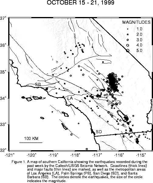
The automatic processing system detected and located 1,505 earthquakes in the past week. Click here to see a summary and map .
The most prominent earthquake of the week, a Mw7.1 located in the Mojave Desert 31 miles north of Joshua Tree, was felt by most people in southern California and a few as far as Las Vegas and Phoenix, as well. The event produced a 40-km long right-lateral strike-slip surface rupture (all contained within the Twentynine Palms Marine Base), and also produced a large number of aftershocks, whose epicenters outline that surface rupture. The total number of events listed above comes from the edited version of the automatic earthquake catalog, and represents a minimum number. The final tally for this time period will probably end up two or three times that number. Thorough data processing should also improve the precision of the locations and narrow the "blob" of aftershocks down to a nice linear feature.
The largest aftershocks were a pair of M5.8's, one at 2:59 am and one at 5:57 am on the 16th. Readers should look at the USGS Pasadena Office web site for several special reports.
Yesterday evening, there was a short spate of large aftershocks: a M4.3 at 6:25 pm, a M4.5 at 6:54:06 pm, a M5.0 at 6:54:35 pm, and another M5.0 at 6:57 pm. The two M5.0's were felt as far away as the Pasadena area.
In addition to the Hector sequence, there were also swarms in the Brawley Seismic Zone. One sequence under the Salton Sea north of Obsidian Butte started with a M4.0 at 3:49 am on the 16th and lasted for about one day. Another started in the Westmorland area, beginning on the morning of the 17th and continuing through the morning of the 19th. Some activity south of the U.S./Mexico border occurred on the 17th through the 19th, as well. It is tempting to attribute this southern activity to some sort of triggering effect of the Mw7.1, but that would be conjectural, since we do not know what the physical mechanism would be.
Needless to say, we will be behind on our data processing for quite awhile now. We should be able to start updating the "Commentary" again, however. I doubt we will be listing every aftershock above M2.5, however!
Here is a brief summary of the Hector aftershock sequence so far. There have been a total of 148 quakes above M3.0, including the mainshock. Of these, 29 have magnitudes of M4.0 or larger (note that the times given are Greenwich times; subtract seven hours to get PDT):
	UTC date    UTC time     Lat.     Long.       Mag.    Deoth
	1999 10 16   9 46 44.60  34 35.73-116 16.09 C 7.0      5.99
	1999 10 16  10  2 41.71  34 34.89-116 22.26 C 4.7      6.00
	1999 10 16  10  4 52.73  34 34.80-116 10.80 C 4.3      3.85
	1999 10 16  10  7 28.33  34 53.85-116 14.86 C 4.7      6.00
	1999 10 16  10  9 54.82  34 38.85-116 17.47 C 4.4      0.15
	1999 10 16  10 10 48.54  34 39.01-116 15.58 A 4.3      2.10
	1999 10 16  10 20 52.92  34 22.70-116  7.86 C 4.6      6.00
	1999 10 16  11  4 33.66  34 22.24-116 12.79 C 4.0      6.00
	1999 10 16  11  6 38.80  34 35.26-116 17.37 C 4.2      6.00
	1999 10 16  11 27 39.07  34 40.61-116 13.37 C 4.3     11.97
	1999 10 16  11 47 44.33  34 41.21-116 21.21 C 4.0      6.00
	1999 10 16  11 49 59.50  34 43.22-116 20.90 C 4.1      6.00
	1999 10 16  12  3 19.09  34 42.93-116 19.02 C 4.4      6.00
	1999 10 16  12 55  9.93  34 29.16-116 15.65 A 4.5      2.37
	1999 10 16  12 57 21.03  34 26.45-116 15.04 A 5.8      1.00
	1999 10 16  13 22 10.52  34 33.07-116 16.51 A 4.0      0.04
	1999 10 16  13 51 17.62  34 26.90-116 13.77 A 4.2      1.46
	1999 10 16  13 59 16.66  34 50.64-116 20.24 C 4.2      0.11
	1999 10 16  17 38 48.54  34 26.35-116 14.40 A 5.0      0.08
	1999 10 16  18  1 52.99  34 39.27-116 24.44 C 4.3      9.24
	1999 10 16  20 13 37.99  34 41.37-116 16.68 C 4.7      6.02
	1999 10 16  21 10 50.68  34 40.29-116 20.40 C 4.1      5.99
	1999 10 16  22 53 41.30  34 42.30-116 21.48 C 4.6      5.97
	1999 10 17   4 22  0.21  34 37.78-116 13.23 C 4.2      5.98
	1999 10 17   4 22 48.86  34 49.51-116 22.28 C 4.2      6.00
	1999 10 17  16 22 48.22  34 21.10-116  8.35 A 4.3      0.87
	1999 10 17  16 32 53.26  34 21.71-116  8.29 D 4.2      0.00
	1999 10 18   6 35 47.37  34 21.30-116  8.72 A 4.6      1.44
	1999 10 18  11  2 20.46  34 50.73-116 21.04 C 4.4      6.01
Field geologists from the U.S. Geological Survey and the California Division of Mines and Geology report finding a 40-km long surface rupture, showing right-lateral strike slip on the Lavic Lake fault. This fault was recognized and mapped previously, but was not extensively studied or named.
For further information on the Hector earthquake and the Lavic Lake fault, see the U.S. Geological Survey Pasadena Office web site .
Immediately after the Hector quake, there was also a sequence of activity under the southern part of the Salton Sea, about halfway between Obsidian Butte (a common source of small quakes) and the southern end of the San Andreas fault at Bombay Beach. The largest was and the first was a M4.0 at 3:49 am. Although this area produces quakes from time to time, this particular swarm formed a lineation parallel to the San Andreas fault, which raised a few eyebrows. Like the Hector quake, however, this sequence seems to be dying off in almost a textbook manner.
There is a small cluster of events going on this morning 31 miles north of Joshua Tree. The three largest events so far are: a M3.0 at 7:22 am, a M2.5 at 7:43 am, and a M2.7 at 9:35 am. This epicenter is in a small off-fault blob on Landers aftershocks.
We recorded and analysed 197 earthquakes in the past week. Click here to see a summary and map .
The largest quake overnight was a M3.0 at 9:56 pm, located 5 miles west-southwest of Salton City. We've gotten no inquiries about it.
The only other event of interest was smaller, a M2.5 located 12 miles north-northeast of Trona. It occurred at 12:52 am.
There was yet quake along the California/Nevada border at 8:46 am this morning. The magnitude was M3.4, and the epicenter was 56 miles north-northeast of Stovepipe Wells.
There was another quake this morning 54 miles north of Stovepipe Wells (or 72 miles east of Bishop). The time was 10:40 am, and the magnitude was M3.3. Because of the remote location, we are unlikely to get any "felt reports".
Aside from this, the only activity worth mentioning was a pair of M2.7's. The first occurred at 12:17 am today, in the San Bernardino Mtns. 6 miles west-northwest of Mt. San Gorgonio. The other was actually in northern Mexico, 15 miles southwest of Ocotillo (due south of Jacumba), and occurred at 9:01 am this morning.
You may be noticing a barrage of bogus earthquake's on the system this afternoon. Be assured that, so far at least, they are all telemetry glitches (on the Army Corps of Engineers microwave system, which we use to transport some of our signals). We are deleting the non-earthquakes as fast as possible, but they are happening faster.
We had a pair of M3 quakes today, in the California/Nevada border region, 55 miles north of Stovepipe Wells. There was a M3.6 at 10:58 am and a M3.5 at 11:29 am.
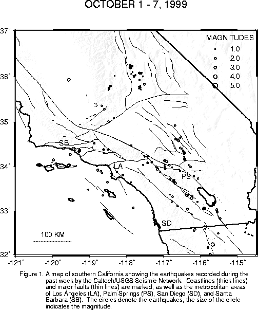
We recorded and analysed 238 earthquakes in the past week. Click here to see a summary and map .
At 1:15 pm this afternoon, a M3.4 quake occurred 5 miles east of Carpinteria. We have no reports that it was felt, but it probably was. The focal mechanism was oblique thrust. Note that there have been a several quakes in the M2 range, at two different locations in southwestern Ventura Basin, in the past few days.
Immediately after the Carpinteria quake, at 1:29 pm, there was a M2.5 located 5 miles north of Anza. That one is less likely to have been felt.
There was a fair amount of microearthquake activity over the weekend, including a M2.9 at 10:38 pm on Friday, located 7 miles east-northeast of Borrego Springs.
Early Saturday morning at 12:08 am, there was a M2.7 located 8 miles north-northeast of Yucaipa.
Then, early Sunday morning at 4:04 am, a M3.0 occurred 8 miles southeast of Olancha. There have been a number of small quakes at this location in the past week or two.
Also on Sunday morning, a small swarm started 16 miles south of Salton City. Events included a M3.4 at 4:54 am, a M2.9 at 4:56 am, a M2.9 at 6:25 am, yet another M2.9 at 6:30 am, and a M2.5 at 9:13 am on Monday (today).
On Sunday afternoon, at 5:20 pm, there was a M2.8, located 1 miles southwest of Obsidian Butte, in Imperial Valley.
Perhaps surprisingly, there were no "felt" reports.
There were two quakes of interest last night: a M2.9 at 5:50 pm, located 51 miles northwest of Bakersfield, not far from Alpaugh, and a M3.3 at 6:29 pm, located 8 miles southeast of Olancha. Neither, as far as we know, was felt. Note that we have seen several quake in the M2 and M3 range in the Olancha location in the past week.
![]()