
A M3.3 quake just occurred, at 3:37 pm, located offshore, 6 miles northwest of Pt. Sal. It has not been reported felt.
There was a little bit of seismic action over the weekend. A M3.1 quake was felt in the Banning and Beaumont areas at 7:00 am on Saturday. The location was 3 miles north of Beaumont.
We also saw a number of quakes in northern Baja, 22 miles south-souteast of Calexico, to be exact. There was a M3.1 at 8:59 pm and a M3.2 at 9:02 pm on Saturday (PDT), and a M3.3 at 12:13 pm on Sunday (PST).
There was also a M2.7 Hector aftershock at 7:27 am on Sunday, located 27 miles north-northeast of Joshua Tree, but it is unlikely that anyone felt it due to its remote location.
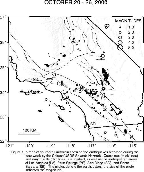
The week's earthquake list totals 258 this week. Click here to see a summary and map .
Early this morning, at 4:53 am, a M3.1 Landers aftershock occurred 2 miles north-northeast of Yucca Valley. It was reported felt in Yucca Valley and Joshua Tree.
A close pair of quakes occurred over the weekend, 25 miles northwest of Baker, on the Fort Irwin Military Reservation. They measured M3.6 and M3.7, and occurred at 7:54:12 am and 7:54:26 (14 seconds apart), on Sunday morning. Note that these locations are outside of the aftershock zone for the Hector sequence, so the quakes were not aftershocks.
At 1:41 am today, there was a M3.0 quake in the northern Imperial Valley, 4 miles southwest of Niland. Also, at 7:02 am today, there was a M3.4 quake in Nevada, 35 miles east-northeast of Furnace creek (Death Valley) CA. Neither has been reported felt.
We have recorded and located 295 earthquakes in the past week. Click here to see a summary and map .
There was another M2.8 this morning ... this time 4 miles north-northeast of Banning. The time was 3:53 am. We have not got any "felt" reports on it.
... and another! There was a Fillmore aftershock at 2:51 pm today, located 12 miles north of Fillmore.
Another aftershock of last Thursday's Fillmore quake occurred at 2:30 pm today. Magnitude was M2.8 and the epicenter was located 11 miles north of Fillmore.
Orange County experienced a small, but quite feelable, quake this morning at 11:58 am. The magnitude was M2.8, and the epicenter was located 3 miles east of Fullerton. "Felt" reports have been received from Brea, Anaheim, Fullerton, Placentia, Yorba Linda, Santa Ana, Orange, and Riverside ... basically most of Orange County and then a little more.
Also, there were two quakes 13 miles north of Fillmore early this morning: a M2.7 at 4:40 am and a M2.6 at 6:21 am. These are aftershocks of last Thursday's M3.9 at the same location.
The largest quake over the weekend was a M3.8 in Nevada, about 48 miles north of Stovepipe Wells (which is in Death Valley), at 9:53 pm on Friday. Other activity included a M2.8, 3 miles southwest of Niland (eastern Imperial Valley) at 1:04 am on Saturday and a M2.8, 5 miles northwest of Olancha (southern Owens Valley), at 8:32 am Saturday. We have no indication that any of these quakes was felt.
Here are the Quarterly Statistics! The Hector total still has the "+", mean that the figure is a minimum number, because we haven't totally finished the processing yet. We believe that we have most of the M3.0 and greater events, however (so no "+"). The number of M3.0+ in the Hector time period (fourth quarter 1999) went down a bit from the previous edition of the statistical report. This reflects the fact that some events have been "demoted" after a closer look, and also a few events had been processed twice, leading to duplicate entries in the catalog.
-------------------------------------------------------------------- Totals listed below apply to the area within a polygon bounded by the following latitude, longitude pairs: 35.0N, 121.0W; 37.0N, 119.0W; 37.0N, 115.0W; 32.5N, 115.0W; and 32.5N, 121.0W.1st quarter 2nd quarter 3rd quarter 4th quarter all 3.0+ all 3.0+ all 3.0+ all 3.0+ 1986 3,040 16 2,865 19 6,634 192 2,300 38 1987 1,679 24 1,887 36 2,341 38 5,748 198 1988 2,749 40 2,128 45 2,195 30 2,208 27 1989 2,528 46 2,340 21 2,323 19 2,335 26 1990 2,850 56 2,293 43 1,859 27 2,039 31 1991 1,679 10 1,843 32 2,081 21 2,337 27 1992 3,389 37 10,084 741 25,849 808 9,775 181 1993 4,799 41 5,152 58 5,039 46 4,419 34 1994 10,735 418 5,766 42 5,221 48 4,813 39 1995 3,639 28 3,788 37 8,252 88 7,733 49 1996 5,735 56 3,966 32 3,690 23 4,660 50 1997 3,699 39 3,276 54 3,193 31 2,443 27 1998 3,590 56 2,830 27 2,655 37 2,352 29 1999 2,253 35 2,546 58 2,555 36 9,529+ 477 2000 5,295 72 4,441 75 3,964 38 --------------------------------------------------------------------
Early this morning, at 4:37 am, there was a M3.2 quake in the northern Imperial Valley, 4 miles southwest of Niland. It was followed at 5:50 am by a M2.7 at the same location. Although the larger of the two could easily have been felt, we have not received any inquiries.
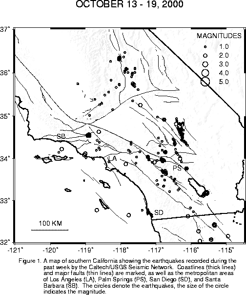
We have recorded and located 246 earthquakes in the past week. Click here to see a summary and map .
We have a revised location for this morning's quake: 12 miles north of Fillmore. The magnitude remains at M3.9. The focal mechanism shows strike-slip. Of minor scientific interest is the fact that many quakes in the general area of Ventura Basin and the surrounding mountains have depths a little greater than what we see in the rest of southern California. This particular quake took place about 27 km (about 17 miles) below the surface, whereas most of our quakes in other areas are shallower than about 20 km.
A M3.9 earthquake occurred this morning, at 9:51 am, located about 14 miles north-northwest of Fillmore. This is an unpopulated, mountainous area due west of Castaic Lake. So far, we have reports that the quake was felt from Ojai and Ventura on the west, to the Grapevine area on the north, to the I14 corridor on the east.
There was a M3.3 earlier this afternoon, at 12:30 pm. It occurred in the San Joaquin Valley, about 36 miles west-northwest of Bakersfield. For those familiar with the area, this is not far from the Lost Hills (route 46) exit off the I5. So far, we've received no "felt" reports.
A pair of M3.2 quakes occurred late Saturday afternoon. The first occurred at 5:17 pm, 7 miles south-southwest of Bakersfield. It was reported felt in the Bakersfield area. The second, which occurred at 5:50 pm, was a Hector aftershock, located 34 miles south-southwest of Baker. This is a very sparsely populated area, so it was probably not felt. In spite of the common "Baker" in the geographic references, the two quakes are considered unrelated.
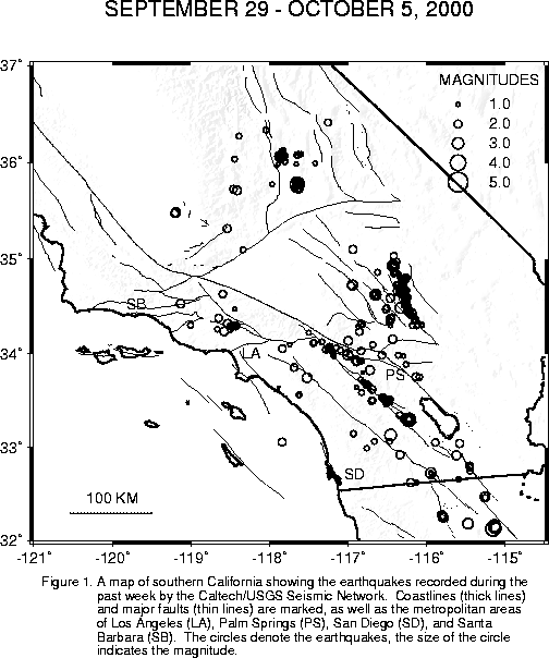
We have recorded and located 407 earthquakes in the past week. Click here to see a summary and map .
There was another M2.9 Hector aftershock this morning, at 4:15 am. It was located 31 miles southwest of Baker.
There was a Hector aftershock, magnitude M2.8, at 10:07 pm last night. The epicenter was 24 miles north of Joshua Tree. There have been no "felt" reports.
A M3.6 quake occurred earlier this evening, at 7:44 pm, 11 miles north of Ridgecrest. It was felt in the Ridgecrest and Trona areas.
Also, at 8:31 pm this evening, a M2.1 Northridge aftershock was fairly widely felt from Topanga Canyon to the mid-San Fernando Valley. The epicenter was located 1 mile east-northeast of Chatsworth. People seem to be feeling exceptionally small earthquakes lately!
There were scattered small earthquakes in southern California this weekend:
For example, there was a very small quake felt (M2.3) in the Lake Elsinore area at 11:25 pm Friday night. The epicenter was 8 miles south-southeast of Corona, or 12 miles west-northwest of Lake Elsinore.
There was a M2.5 at 2:58 am on Saturday, located 3 miles south-southeast of Yucaipa. There were no "felt" reports on this one.
There were also a handful of Baja events. The largest was a M3.8 at 2:46 pm on Saturday, located 41 miles south-southeast of Calexico. The automatic system mistakenly place this event near Anza (M3.0). The event has now beem correctly processed and should update on the map shortly.
Then, at 9:38 pm last night, there was a M3.0 Landers (not Hector) aftershock. The epicentral location was 20 miles northeast of Lucerne Valley.
Also last night, there was a M2.8 in the Ocotillo area, near the U.S./Mexico border. The time was 11:59 pm and the location was 2 miles east-southeast of Ocotillo.
Another M3.0 occurred about 5:17 am this morning. It's epicenter was located 9 miles east-northeast of Julian.
Finally, another very small quake (M2.0) was reported felt at 7:19 am. This quake had a location 2 miles west of Banning.
![]()