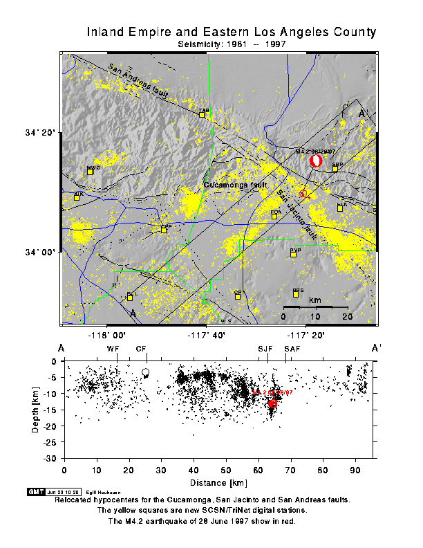
A M4.2 earthquake occurred on 28 June 1997 at 2:45 pm. The quake was located 4 miles NNW of the City of San Bernardino, in San Bernardino County.
  Preliminary Location :  34 deg.  9.8 min.
                         -117 deg. 20.6 min. -13.1 km depth
The event caused light shaking throughout the region, with maximum recorded
acceleration of 3% in Highland, east of San Bernardino. This event is not
an aftershock of a previous larger earthquake. The M4.2 has so far been
followed by three aftershocks in the M2 to 2.2 range.
This M4.2 quake appears to be associated with the San Jacinto fault.
It occurred near a step-over where the ground is being pulled apart.
It does not appear to be associated with the San Andreas fault that is
located to the east (see the figure below).
The solid, dashed, and dotted lines are fault lines. The San Andreas fault strikes to the west-northwest toward Palmdale, while the San Jacinto fault strikes to the southwest toward Hemet. The freeways are shown in blue.
A northeast striking cross section (A-A') is shown at the bottom of the Figure. The M4.2 earthquake is shown by its focal mechanism, which identifies two possible causative fault planes. The east dipping nodal plane of the focal mechanism suggests that this strand of the San Jacinto fault may cut the earth's surface near Fontana to the west.
The San Jacinto fault is the most active fault in southern California in terms of earthquake activity recorded this century. The San Andreas fault is the fastest moving fault although far fewer small or moderate-sized events occur near it.
Southern California Earthquake Center Data Center Home Page
U.S. Geological Survey - Pasadena Home Page